
Calling from the Moon
- Sep 18, 2021
- 7 min read
Updated: Dec 24, 2021
History of Communication Satellites in a Nutshell
These days we can call up someone in the remotest parts of Antartica and have a conversation as though they were right next to us. However, without the nifty technology that is the ‘Satellite’, none of this would be possible.
They were first mentioned by Arthur C. Clarke (author of ‘2001: A Space Odyssey’) in his article ‘Wireless World’ written in 1945, where he described the transmission of TV programmes from manned satellites in 24-hour orbit around Earth; and then later looked at in detail by John R. Pierce in 1951-2, paving the way to the first communication satellite to be launched in 1957: Sputnik 1.

Sputnik 1 Replica. Credit: NSSDC, NASA
Following this, many more innovations came and with this, many more communication satellites. From Telstar 1 in 1962 which transmitted the first satellite TV (including images of the Eiffel Tower and Statue of Liberty, since it was sent from Brittany to Maine in north east USA); to e-BIRD: a broadband satellite which provided signal to parts of Europe with none.
As well as their many innovations of everything from what they could transmit to where in Earth’s orbit they were (more on that later), communication satellites have also famously been getting smaller; a lot smaller. The small light (from 1 to 10kg) nanosats have become very popular in recent years: ever since the first six in June 2003, they’ve been providing an affordable way to collect data and send it back to Earth, needing little fuel to send them into Space and little material to make them.
Another miniaturising innovation is the the smallsat: a satellite class slightly bigger than the nanosat at less than 180kg. They have been especially popular as communication satellites; most notably with Starlink and OneWeb. Aside from the disruption of Earth-based astronomy, their focus is on fast global broadband, reaching places that couldn’t get an internet connection before using much cheaper methods than older broadband satellites to provide more universal coverage [1][2][3][4][5][6][7].

Model of OneWeb Satellite. Credit: NASA/Kim Shiflett
Where are they?
The simple answer is, of course, in orbit around Earth. However, Earth’s orbit is a very big place, so there are various common orbit types: Geostationary Orbit (GEO), Low Earth Orbit (LEO), Medium Earth Orbit (MEO), Polar Orbit and Sun-Synchronous Orbit (SSO), Transfer Orbits and Geostationary Transfer Orbits (GTO) and the Lagrange Points (L-points) [8].
First, let’s look at GEO: 35,786km above Earth and travelling west to east to follow the rotation of the Earth along the equator, thereby staying above the same place on Earth at all times. They can serve large sections of Earth with constant coverage, and so ensure that area always gets coverage (for relaying signals, for instance) or is continually monitored (like with weather satellites) [8].
LEO is, as the name suggests, low: less than 1000km high to be specific, following any plane (angle of orbit) they want, meaning there’s lots more space for satellites. This makes them fantastic for imagery satellites, but not so for satellite communications, since they’re travelling so fast, orbiting 16 times a day. However, mega-constellations like those of Starlink and OneWeb are in LEO, so how? It’s down to the fact they work together to cover the whole Earth at once, seamlessly changing the satellite in use after the previous one used is out of range. All this makes it extremely popular, whilst also creating a mine field of space debris [8][9].
And where does our prized GPS fit into all this? Well, GPS satellites (along with other navigation satellites such as ESA’s Galileo system) orbit in MEO, found between LEO and GEO. They have the advantages of a lower time to send signals than in GEO, a larger footprint across Earth than LEO, and the option of going in any plane around Earth [8][10].
Like LEO, SSO orbits at a similar altitude (600-800km) and does what it says on the tin: it orbits so, relative to the Sun, it’s fixed in the same position all the time, flying over certain locations at the same time each day and going over the North and South Poles within 20-30 degrees. This is helpful in seeing changes over time at certain places [8].

Scale diagram of where the orbits around Earth are.
Credit: Rrakanishu, CC BY-SA 4.0
Want to use little fuel but still want to go all the way to GEO? Simple; use GTO: putting a satellite into a GTO when offloaded will let them move, with little use of the satellite’s energy, into a higher orbit. This is because it’s an elliptical instead of circular orbit, with two foci instead of one (points where a curve is constructed) — in other words, a stretched circular orbit [8].
However, what if you want to go much much further out? This is where the Lagrange Points come in. Totalling five, they are the points far away (1.5 million km) from Earth where a satellite can have a stable orbit, found using some cool maths curtesy of one Joseph-Louis Lagrange [8][11].
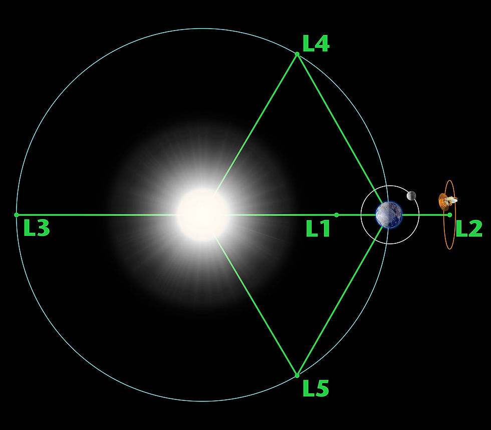
Where the Lagrange Points are relative to the Earth and the Sun.
Credit: NASA/WMAP Science Team
How to Navigate and Phone from Space
What do we do if we don’t have this massive network of satellites though, like when you’re a spacecraft flung off into the far reaches of Space? That’s where NASA’s Deep Space Network (DSN) and ESA’s Deep Space Antennae (DSA) come in. They are groups of enormous radio antennae (everywhere from Madrid in Spain, to just north of Perth in Australia) which transmit and receive data, used for telemetry (receiving the scientific data spacecraft collect) and command (controlling what the spacecraft does) [12][13].
However, as well as this, they also help with the problem of navigation in Space. The antennae send signals to the spacecraft and time how long it takes to arrive at a receiving dish after a signal has been transmitted by the spacecraft, determining: how fast the craft is travelling, its distance from Earth, and where the spacecraft is in the sky. A signal can then be transmitted to instruct the spacecraft as to how it can change its course [13][14][15].

A 70m antenna in Robledo de Chavela near Madrid, Spain, used in NASA's DSN
Credit: Hector Blanco de Frutos, CC BY 2.5
That said, on longer missions, it may take many minutes, hours or days to do this (around 2.7 days for the Voyager 1 probe to receive, send and then receive a signal [16]). This is where pulsars come in: neutron stars (dying massive stars) which send regular pulses of light from their poles as they rotate. The spacecraft can use three sources of these pulses (the quicker the more precise) to measure changes in the timing between each pulse, thereby pinpointing its location in space [15].
Navigation and Communication on the Moon
Unlike the far reaches of Space, the Moon is much much closer. This means that some Earth based technology already in place can be used: notably our global navigation systems, such as GPS. Their signals may be directed towards Earth, but some signal spills over into Outer Space. And some engineers think we could use that ‘spill-over signal’ to navigate, though the signal would be pretty weak [15].
This is where a new generation of satellites come into play: ones which take out the time issues; the weakness of signals and the trouble with a body like the Moon coming between you and the Earth. It’s called Lunar Pathfinder [17].
With the help of Surrey Satellite Technology Ltd (SSTL - announced on 16th September), a satellite manufacturer based just outside Guildford in central Surrey, ESA will put a single satellite into orbit around the Moon in 2024 to provide continuous communication services for both robots and humans on the lunar poles and its far side (the side which never faces Earth) because there are thought to be sources of oxygen, rocket fuel and water in those locations [17][18].
It will also hold three experiments: an ESA receiver to detect the signals from GPS and Galileo (ESA’s version of GPS) from Earth, demonstrating the possibility of Lunar navigation with the aid of Earth and Moon based satellites; a NASA mirror (or retro-reflector) to demonstrate the possibility of laser ranging (tracking the positions of the satellites by measuring the laser light reflect off them [19]); and an ESA radiation detector to measure levels of radiation in orbit [18].
To do all this, the Lunar Pathfinder satellite will be put into a lunar orbit called an ‘Elliptical Lunar Frozen Orbit (ELFO). The ‘frozen orbits’ are where spacecraft can orbit the Moon at a low altitude (800-8,800km) indefinitely (though this satellite will end its mission after 8 years), and at a range of inclinations (angles of orbit): 27º, 50º, 76º and 86º (very close to those all important Lunar polar regions) [20][21].
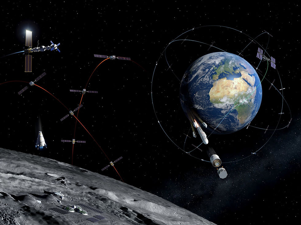
Image showing the various missions which are part of the future lunar initiatives including NASA's Artemis programme and ESA's Moonlight programme.
Credit: ESA
In years to come, we may have an array of satellites helping our astronauts and robots on the Moon find where they are and communicate with the same ease we enjoy on Earth.
by George Abraham, ADAS member.
Click here for the previous news article
Click here for the next news article
Click here to look at the current state of NASA's Deep Space Network (DSN)
Click here to see where ESA's Deep Space Antennae are located
Click here to look at how ESA's Ground Stations are doing (which include ESA's Deep Space Antennae) - found at the bottom of the page
References
"Communications Satellites: Making the Global Village Possible". NASA. Archived from the original on 18th September 2021.
"A Brief History of Satellite Communications". Ground Control. Archived from the original on 18th September 2021.
"Cubesats: Tiny Payloads, Huge Benefits for Space Research". Space.com. Archived from the original on 18th September 2021.
"Starlink". Starlink. Archived from the original on 18th September 2021.
"July 12, 1962: The Day Information Went Global". NASA. Archived from the original on 18th September 2021.
"Telestar 1 Legacy: 1st Live TV Broadcast by Satellite Turns 50". Space.com. Archived from the original on 18th September 2021.
"What are SmallSats and CubeSats?" NASA. Archived from the original on 18th September 2021.
"Types of Orbits". ESA. Archived from the original on 18th September 2021.
"What is Low Earth Orbit?" Universe Today. Archived from the original on 18th September 2021.
"Popular Orbits 101". Aerospace Security. Archived from the original on 18th September 2021.
"What are Lagrange Points?" ESA. Archived from the original on 18th September 2021.
"What is the Deep Space Network?" NASA. Archived from the original on 18th September 2021.
"DSN Function". NASA. Archived from the original on 18th September 2021.
"Navigation in Deep Space". Time and Navigation. Archived from the original on 18th September 2021.
"Deep Space Communication and Navigation". ESA. Archived from the original on 18th September 2021.
"Mission Status". Voyager. Archived from the original on 18th September 2021.
"Path set for commercial communications around the Moon". ESA. Archived from the original on 18th September 2021.
"Lunar Mission Services". SSTL Lunar. Archived from the original on 18th September 2021.
"Welcome to ILRS". ILRS, NASA. Archived from the original on 18th September 2021.
"Bizarre Lunar Orbits". NASA. Archived from the original on 18th September 2021.
"Options for Staging Orbits in Cislunar Space". NASA. Archived from the original on 18th September 2021.


Comments